
Make a donation
Gear up for your next adventure:
As an Amazon Associate, this site earns from qualifying purchases at no extra cost to you.
Nangalisan topographic map
Click on the map to display elevation.
Make a donation
Gear up for your next adventure:
As an Amazon Associate, this site earns from qualifying purchases at no extra cost to you.
About this map
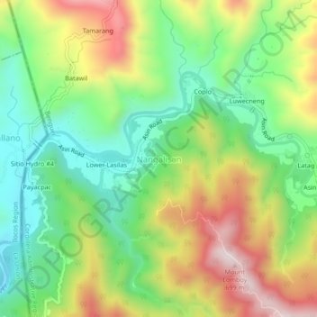
Name: Nangalisan topographic map, elevation, terrain.
Average elevation: 356 m
Minimum elevation: 134 m
Maximum elevation: 678 m
Make a donation
Gear up for your next adventure:
As an Amazon Associate, this site earns from qualifying purchases at no extra cost to you.
Other topographic maps
Click on a map to view its topography, its elevation and its terrain.
Ambuklao Dam
Philippines > Benguet > Ambuclao > Ambangol
SNAP-Benguet began a massive rehabilitation project that restored Ambuklao to operating status and increased its capacity from 75 MW to 105 MW. The project required the construction of a new intake, headrace and penstock, elevation of tailrace tunnel outlet, de-silting of tailrace tunnel and replacement of…
Average elevation: 808 m
Waiting shed at the OPAg building, Wangal
Philippines > Benguet > La Trinidad > Upper Wangal
Average elevation: 1,352 m