
Make a donation
Gear up for your next adventure:
As an Amazon Associate, this site earns from qualifying purchases at no extra cost to you.
Kleinwelka topographic map
Click on the map to display elevation.
Make a donation
Gear up for your next adventure:
As an Amazon Associate, this site earns from qualifying purchases at no extra cost to you.
Kleinwelka
Eine wichtige Rolle spielte ab 1778 das Internat für Kinder von Missionaren (Knaben- und Mädchenanstalt). Bis zu 140 und insgesamt über 2.000 Missionskinder kamen ab sechs Jahren über mehrere Jahre zur schulischen Ausbildung aus Labrador, Suriname, Tansania und Natal nach Kleinwelka und wechselten in höheren Klassen an das Herrnhuter Pädagogium in Niesky über.
Make a donation
Gear up for your next adventure:
As an Amazon Associate, this site earns from qualifying purchases at no extra cost to you.
About this map
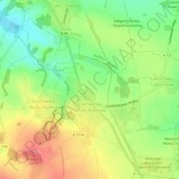
Name: Kleinwelka topographic map, elevation, terrain.
Location: Kleinwelka, Bautzen, Sachsen, Deutschland (51.20561 14.38643 51.22119 14.40710)
Average elevation: 205 m
Minimum elevation: 167 m
Maximum elevation: 245 m
Make a donation
Gear up for your next adventure:
As an Amazon Associate, this site earns from qualifying purchases at no extra cost to you.
Other topographic maps
Click on a map to view its topography, its elevation and its terrain.