Geolocate

Alvaton topographic map

Click on the map to display elevation.

About this map

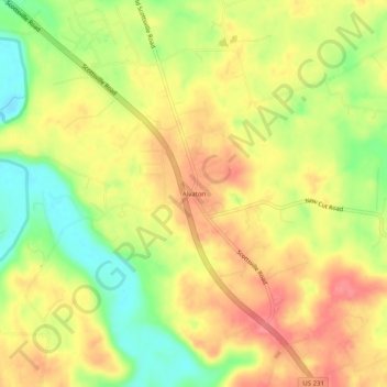
Name: Alvaton topographic map, elevation, terrain.

Location: Alvaton, Warren County, Kentucky, 42122, United States (36.85338 -86.37305 36.89338 -86.33305)

Average elevation: 182 m

Minimum elevation: 139 m

Maximum elevation: 214 m

Gear up for your next adventure:

📷Camera Straps - Secure straps for carrying cameras while walking
📸Action Camera Chest Mounts - Record your ascent following topographic paths hands-free
🧘Folding Sit Mats - Dry and warm seat for map-reading breaks on damp ground
🪓Outdoor Multitools - Versatile tools for hiking and camping
🧤Hiking Gloves - Warm and durable gloves for cold-weather walks

As an Amazon Associate, this site earns from qualifying purchases at no extra cost to you.