Geolocate

Mayo-Oulo topographic map

Click on the map to display elevation.

About this map
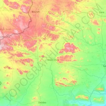
Name: Mayo-Oulo topographic map, elevation, terrain.

Location: Mayo-Oulo, Mayo-Louti, North, Cameroon (9.75415 13.24685 10.25946 13.89024)

Average elevation: 571 m

Minimum elevation: 236 m

Maximum elevation: 1,229 m

Other topographic maps

Click on a map to view its topography, its elevation and its terrain.
Gorom

Cameroon > North > Mayo-Louti > Guider

Average elevation: 429 m

Gear up for your next adventure:

🧥Breathable Waterproof Jackets - Essential rain protection for the unpredictable British climate
🎒Hiking Backpacks - Comfortable backpacks for day hikes and multi-day treks
🛑Emergency Bivvy Bags - Heat-reflective survival bags for unexpected nights out
🧰First Aid Kits - Essential safety kits for outdoor activities
🔥Emergency Fire Starters - Reliable ignition tools for survival situations in damp conditions

As an Amazon Associate, this site earns from qualifying purchases at no extra cost to you.