
La cumbre topographic map
Interactive map
Click on the map to display elevation.
About this map
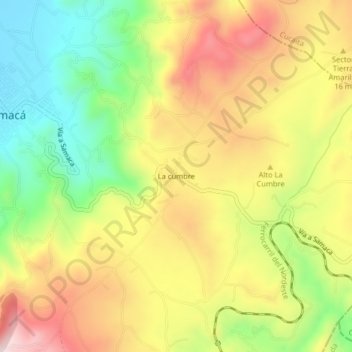
Name: La cumbre topographic map, elevation, terrain.
Location: La cumbre, Samacá, Centro, Boyacá, 154067, Colombia (5.46481 -73.48576 5.50481 -73.44576)
Average elevation: 2,822 m
Minimum elevation: 2,591 m
Maximum elevation: 3,062 m
Other topographic maps
Click on a map to view its topography, its elevation and its terrain.