
Karavilai topographic map
Interactive map
Click on the map to display elevation.
About this map
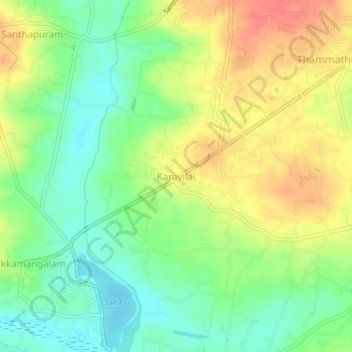
Name: Karavilai topographic map, elevation, terrain.
Average elevation: 28 m
Minimum elevation: 3 m
Maximum elevation: 55 m
Other topographic maps
Click on a map to view its topography, its elevation and its terrain.
Kanyakumari
India > Tamil Nadu > Agastheeswaram
Kanniyakumari is located at 8°05′N 77°34′E / 8.08°N 77.57°E / 8.08; 77.57. and has an average elevation of 30 metres. The peninsular tip of Kanniyakumari is bordered on three sides by the Laccadive Sea. It is located at the confluence of the Western Coastal Plains and Eastern Coastal Plains.
Average elevation: 6 m