
Swedesboro topographic map
Interactive map
Click on the map to display elevation.
About this map
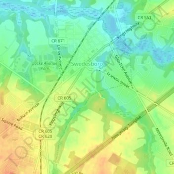
Name: Swedesboro topographic map, elevation, terrain.
Location: Swedesboro, Gloucester County, New Jersey, United States (39.73223 -75.32009 39.75571 -75.30153)
Average elevation: 18 m
Minimum elevation: -1 m
Maximum elevation: 38 m
Other topographic maps
Click on a map to view its topography, its elevation and its terrain.
Mantua Grove
United States > New Jersey > Gloucester County > West Deptford Township
Average elevation: 11 m
Parkville
United States > New Jersey > Gloucester County > West Deptford Township
Average elevation: 14 m
Creesville
United States > New Jersey > Gloucester County > Washington Township
Average elevation: 32 m
North Woodbury
United States > New Jersey > Gloucester County > Deptford Township
Average elevation: 9 m
Wolfert
United States > New Jersey > Gloucester County > East Greenwich Township
Average elevation: 15 m
Creesville
United States > New Jersey > Gloucester County > Washington Township > Creesville
Average elevation: 32 m
Jericho
United States > New Jersey > Gloucester County > Deptford Township > Deptford > Jericho
Average elevation: 20 m