
Canaan topographic map
Interactive map
Click on the map to display elevation.
About this map
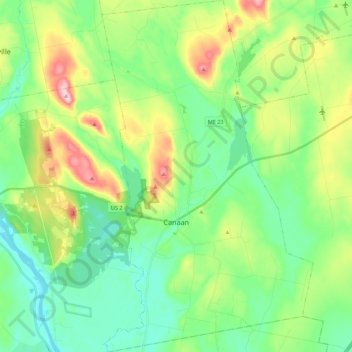
Name: Canaan topographic map, elevation, terrain.
Location: Canaan, Somerset County, Maine, 04924, États-Unis d'Amérique (44.70463 -69.60747 44.85920 -69.47665)
Average elevation: 100 m
Minimum elevation: 30 m
Maximum elevation: 260 m
Other topographic maps
Click on a map to view its topography, its elevation and its terrain.
The Forks Plantation
États-Unis d'Amérique > Maine > Somerset County
The Forks Plantation, Somerset County, Maine, États-Unis d'Amérique
Average elevation: 353 m
Bigelow Preserve
États-Unis d'Amérique > Maine > Somerset County
Bigelow Preserve, Dead River Township, Somerset County, Maine, États-Unis d'Amérique
Average elevation: 460 m