
Tinzaouten topographic map
Interactive map
Click on the map to display elevation.
Tinzaouten
Tin Zaouatine lies at an elevation of 630 metres (2,070 ft) in the far north-western part of the Adrar des Ifoghas mountain range, which lies mostly in Mali. A series of long, rocky ridges run from north-south to the west of the town.
About this map
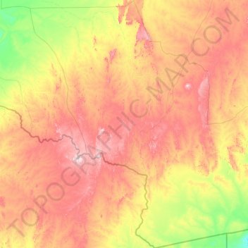
Name: Tinzaouten topographic map, elevation, terrain.
Location: Tinzaouten, Tinzaouaten District, In Guezzam, 11150, Algeria (18.96815 1.77632 21.90395 4.67314)
Average elevation: 578 m
Minimum elevation: 381 m
Maximum elevation: 909 m