
Thank you for supporting this site ❤️
Make a donation
Make a donation
Gear up for your next adventure:
As an Amazon Associate, this site earns from qualifying purchases at no extra cost to you.
Olmos topographic map
Click on the map to display elevation.
Thank you for supporting this site ❤️
Make a donation
Make a donation
Gear up for your next adventure:
As an Amazon Associate, this site earns from qualifying purchases at no extra cost to you.
About this map
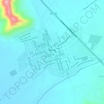
Name: Olmos topographic map, elevation, terrain.
Location: Olmos, Lambayeque, Perú (-5.99515 -79.75537 -5.98222 -79.73588)
Average elevation: 185 m
Minimum elevation: 159 m
Maximum elevation: 369 m
Thank you for supporting this site ❤️
Make a donation
Make a donation
Gear up for your next adventure:
As an Amazon Associate, this site earns from qualifying purchases at no extra cost to you.
Other topographic maps
Click on a map to view its topography, its elevation and its terrain.
Área de Conservación Regional Bosque Huacrupe-La Calera
Perú > Lambayeque > Olmos
Average elevation: 149 m