
Puurs-Sint-Amands topographic map
Interactive map
Click on the map to display elevation.
About this map
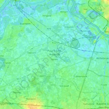
Name: Puurs-Sint-Amands topographic map, elevation, terrain.
Location: Puurs-Sint-Amands, Mechelen, Antwerp, Flanders, Belgium (51.02671 4.18699 51.10186 4.36089)
Average elevation: 5 m
Minimum elevation: -5 m
Maximum elevation: 21 m
Other topographic maps
Click on a map to view its topography, its elevation and its terrain.
Puurs
Belgium > Antwerp > Mechelen > Puurs-Sint-Amands
Puurs sits about 5 meters above mean sea level. Its geography shows only minor elevation differences. Puurs is mainly rural, with some low intensity industry development in the North alongside the N16 expressway. However, because of its proximity to the cities of Antwerp and Brussels (both within a 25 km (16…
Average elevation: 4 m