
Make a donation
Gear up for your next adventure:
As an Amazon Associate, this site earns from qualifying purchases at no extra cost to you.
Nagaur topographic map
Click on the map to display elevation.
Make a donation
Gear up for your next adventure:
As an Amazon Associate, this site earns from qualifying purchases at no extra cost to you.
Nagaur
Nagaur is located at 27°12′N 73°44′E / 27.2°N 73.73°E / 27.2; 73.73. It has an average elevation of 302 metres (990 feet). Nagaur is situated amidst seven districts namely Bikaner, Churu, Sikar, Jaipur, Ajmer, Pali, Jodhpur. Nagaur is the fifth largest district in Rajasthan with a vast terrain spreading over 17,718 km2 (6,841 sq mi) Its geographical spread is a good combine of plain, hills, sand mounds and as such it is a part of the great Indian Thar Desert.
Make a donation
Gear up for your next adventure:
As an Amazon Associate, this site earns from qualifying purchases at no extra cost to you.
About this map
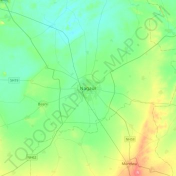
Name: Nagaur topographic map, elevation, terrain.
Average elevation: 303 m
Minimum elevation: 278 m
Maximum elevation: 376 m
Make a donation
Gear up for your next adventure:
As an Amazon Associate, this site earns from qualifying purchases at no extra cost to you.