
Aiguille de la Grande Sassière topographic map
Interactive map
Click on the map to display elevation.
About this map
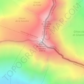
Name: Aiguille de la Grande Sassière topographic map, elevation, terrain.
Average elevation: 3,100 m
Minimum elevation: 2,348 m
Maximum elevation: 3,743 m
Other topographic maps
Click on a map to view its topography, its elevation and its terrain.
Testa del Rutor
Italia > Valle d'Aosta > Valgrisenche
Testa del Rutor, Valgrisenche, Valle d'Aosta, Italia
Average elevation: 3,024 m