
Al Bad topographic map
Interactive map
Click on the map to display elevation.
About this map
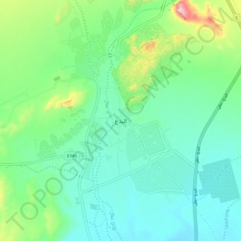
Name: Al Bad topographic map, elevation, terrain.
Location: Al Bad, محافظة البدع, Province de Tabouk, Arabie saoudite (28.44416 34.97411 28.52416 35.05411)
Average elevation: 257 m
Minimum elevation: 183 m
Maximum elevation: 490 m
Other topographic maps
Click on a map to view its topography, its elevation and its terrain.
Neom
Arabie saoudite > Province de Tabouk
Neom, Gouvernorat de Douba, Province de Tabouk, Arabie saoudite
Average elevation: 52 m
Gouvernorat de Douba
Arabie saoudite > Province de Tabouk
Gouvernorat de Douba, Province de Tabouk, Arabie saoudite
Average elevation: 584 m