
Ässån topographic map
Interactive map
Click on the map to display elevation.
About this map
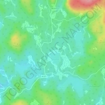
Name: Ässån topographic map, elevation, terrain.
Location: Ässån, Smedjebackens kommun, Dalarna County, Sweden (60.16829 15.72592 60.16857 15.72659)
Average elevation: 184 m
Minimum elevation: 152 m
Maximum elevation: 267 m
Other topographic maps
Click on a map to view its topography, its elevation and its terrain.
Hedemora kommun
Hedemora kommun, Dalarna County, Sweden
Average elevation: 162 m
Rättviks kommun
Rättviks kommun, Dalarna County, Sweden
Average elevation: 300 m
Malung-Sälens kommun
Malung-Sälens kommun, Dalarna County, Sweden
Average elevation: 395 m
Stöten
Stöten, Malung-Sälens kommun, Dalarna County, Sweden
Average elevation: 590 m
Sälen
Sälen, Malung-Sälens kommun, Dalarna County, Sweden
Average elevation: 514 m
Malung
Malung, Malung-Sälens kommun, Dalarna County, 782 31, Sweden
Average elevation: 341 m