
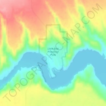
Little Bow Provincial Park topographic map
Interactive map
Click on the map to display elevation.
About this map
Name: Little Bow Provincial Park topographic map, elevation, terrain.
Average elevation: 902 m
Minimum elevation: 852 m
Maximum elevation: 965 m
Other topographic maps
Click on a map to view its topography, its elevation and its terrain.
Drumheller
Canada > Alberta > Division No. 5
Drumheller, Division No. 5, Alberta, T0J 0Y2, Canada
Average elevation: 763 m
Carbon
Canada > Alberta > Division No. 5
Carbon, Division No. 5, Alberta, T0M 0L0, Canada
Average elevation: 812 m
Carseland
Canada > Alberta > Division No. 5
Carseland, Division No. 5, Alberta, T0J 0M0, Canada
Average elevation: 965 m