
Thank you for supporting this site ❤️
Make a donation
Make a donation
Gear up for your next adventure:
As an Amazon Associate, this site earns from qualifying purchases at no extra cost to you.
Tecamalucan topographic map
Click on the map to display elevation.
Thank you for supporting this site ❤️
Make a donation
Make a donation
Gear up for your next adventure:
As an Amazon Associate, this site earns from qualifying purchases at no extra cost to you.
About this map
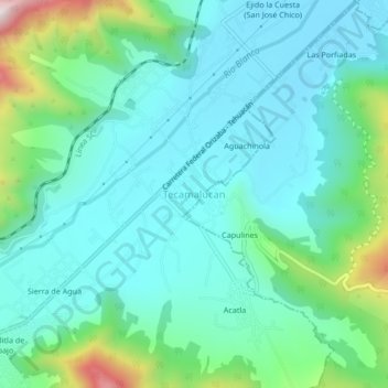
Name: Tecamalucan topographic map, elevation, terrain.
Location: Tecamalucan, Acultzingo, Veracruz, México (18.74056 -97.24417 18.78056 -97.20417)
Average elevation: 1,464 m
Minimum elevation: 1,337 m
Maximum elevation: 1,934 m
Thank you for supporting this site ❤️
Make a donation
Make a donation
Gear up for your next adventure:
As an Amazon Associate, this site earns from qualifying purchases at no extra cost to you.