Geolocate

Maram topographic map

Click on the map to display elevation.

About this map

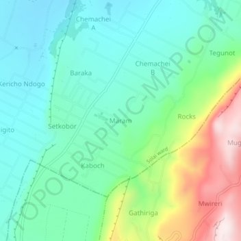
Name: Maram topographic map, elevation, terrain.

Location: Maram, Solai ward, Rongai, Nakuru, Rift Valley, Kenya (-0.04342 36.12413 -0.00342 36.16413)

Average elevation: 1,765 m

Minimum elevation: 1,589 m

Maximum elevation: 2,217 m

Other topographic maps

Click on a map to view its topography, its elevation and its terrain.

Lake Solai

Kenya > Nakuru > Rongai > Solai ward > Lekikor/Siriande

Average elevation: 1,525 m

Gear up for your next adventure:

🧭Emergency Beacons - Safety beacons for remote outdoor locations
🥾Hiking Boot Waterproofing Wax - Maintain the lifespan of your leather trekking boots
🔪Outdoor Multi-Tools - Versatile tools for gear repairs and food prep in the wild
👟Heavy Duty Boot Laces - Always carry a spare for your hiking footwear
🧣Fleece Neck Warmers - Extra insulation for winter topographic surveys

As an Amazon Associate, this site earns from qualifying purchases at no extra cost to you.