Geolocate

Wyke Regis topographic map

Click on the map to display elevation.

About this map

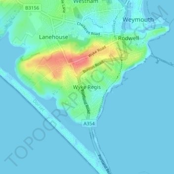
Name: Wyke Regis topographic map, elevation, terrain.

Location: Wyke Regis, Weymouth, Dorset, England, DT4 9BS, United Kingdom (50.57404 -2.49298 50.61404 -2.45298)

Average elevation: 9 m

Minimum elevation: -5 m

Maximum elevation: 67 m

Dorset trails, hiking, mountain biking, running and outdoor activities

Other topographic maps

Click on a map to view its topography, its elevation and its terrain.

Weymouth Bay

United Kingdom > England > Dorset > Weymouth > Preston

Average elevation: 3 m

Gear up for your next adventure:

🧴Sport Sunscreen Sticks - High-protection sunblock that won't run into your eyes on the trail
🧼Biodegradable Soap - Leave-no-trace hygiene for multi-day mountain treks
🗺️Topographic Maps - Detailed maps showing elevation and terrain features
🥤Hiking Water Bottles - Reusable bottles for hydration on the trail
🛌Insulated Sleeping Mats - Crucial thermal protection when sleeping on cold, uneven ground

As an Amazon Associate, this site earns from qualifying purchases at no extra cost to you.