
Nespereira topographic map
Interactive map
Click on the map to display elevation.
About this map
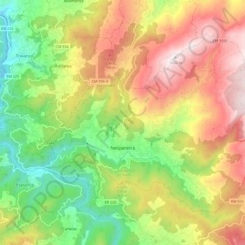
Name: Nespereira topographic map, elevation, terrain.
Location: Nespereira, Cinfães, Viseu, Portugal (40.97847 -8.21335 41.04153 -8.09907)
Average elevation: 489 m
Minimum elevation: 27 m
Maximum elevation: 1,027 m
Other topographic maps
Click on a map to view its topography, its elevation and its terrain.
Pedreles
Portugal > Viseu > Fornos de Maceira Dão > Fornos de Maceira Dão > Pedreles
Average elevation: 447 m
Casal de Cima
Portugal > Viseu > Vilar de Besteiros e Mosteiro de Fráguas > Vilar de Besteiros > Casal de Cima
Average elevation: 338 m