
Thank you for supporting this site ❤️
Make a donation
Make a donation
Gear up for your next adventure:
As an Amazon Associate, this site earns from qualifying purchases at no extra cost to you.
Lemmi topographic map
Click on the map to display elevation.
Thank you for supporting this site ❤️
Make a donation
Make a donation
Gear up for your next adventure:
As an Amazon Associate, this site earns from qualifying purchases at no extra cost to you.
About this map
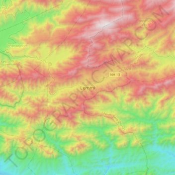
Name: Lemmi topographic map, elevation, terrain.
Location: Lemmi, Pakke Kessang, Pakke-Kessang, Arunachal Pradesh, India (26.99943 93.06067 27.31943 93.38067)
Average elevation: 1,217 m
Minimum elevation: 182 m
Maximum elevation: 2,566 m
Thank you for supporting this site ❤️
Make a donation
Make a donation
Gear up for your next adventure:
As an Amazon Associate, this site earns from qualifying purchases at no extra cost to you.