
Make a donation
Gear up for your next adventure:
As an Amazon Associate, this site earns from qualifying purchases at no extra cost to you.
Barnes Lake topographic map
Click on the map to display elevation.
Make a donation
Gear up for your next adventure:
As an Amazon Associate, this site earns from qualifying purchases at no extra cost to you.
About this map
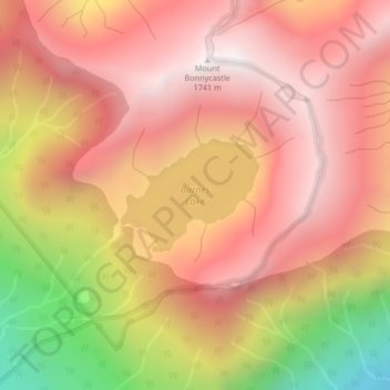
Name: Barnes Lake topographic map, elevation, terrain.
Average elevation: 1,277 m
Minimum elevation: 472 m
Maximum elevation: 1,718 m
Make a donation
Gear up for your next adventure:
As an Amazon Associate, this site earns from qualifying purchases at no extra cost to you.
Other topographic maps
Click on a map to view its topography, its elevation and its terrain.
Lower Seymour Conservation Reserve
Canada > British Columbia > Metro Vancouver Regional District > Electoral Area A
Average elevation: 605 m
Pitt Lake
Canada > British Columbia > Metro Vancouver Regional District > Electoral Area A
Average elevation: 659 m
Tower Beach
Canada > British Columbia > Metro Vancouver Regional District > Electoral Area A
Average elevation: 27 m
Indian Arm
Canada > British Columbia > Metro Vancouver Regional District > Electoral Area A
Average elevation: 463 m
Make a donation
Gear up for your next adventure:
As an Amazon Associate, this site earns from qualifying purchases at no extra cost to you.
Pacific Spirit Regional Park
Canada > British Columbia > Metro Vancouver Regional District > Electoral Area A
Average elevation: 56 m
University of British Columbia
Canada > British Columbia > Metro Vancouver Regional District > Electoral Area A
Average elevation: 57 m
Nitobe Memorial Garden
Canada > British Columbia > Metro Vancouver Regional District > Electoral Area A
Average elevation: 36 m
Mount Eldee
Canada > British Columbia > Metro Vancouver Regional District > Electoral Area A
Average elevation: 1,026 m
Make a donation
Gear up for your next adventure:
As an Amazon Associate, this site earns from qualifying purchases at no extra cost to you.
University of British Columbia
Canada > British Columbia > Metro Vancouver Regional District > Electoral Area A
Average elevation: 64 m