
Make a donation
Gear up for your next adventure:
As an Amazon Associate, this site earns from qualifying purchases at no extra cost to you.
Lac Seul topographic map
Click on the map to display elevation.
Make a donation
Gear up for your next adventure:
As an Amazon Associate, this site earns from qualifying purchases at no extra cost to you.
Lac Seul
Lac Seul is a large, crescent shaped reservoir in Kenora District, northwestern Ontario, Canada. It is approximately 241 km (150 mi) long. It has a maximum (regulated) depth of 47.2 m, with a surface elevation of 357 m above sea level. Its level is raised in the summer and then drawn down in the winter months to reach points of as low as 16 feet below the maximum level. It is the second largest body of water entirely within the province of Ontario (Lake Nipigon being first).
Make a donation
Gear up for your next adventure:
As an Amazon Associate, this site earns from qualifying purchases at no extra cost to you.
About this map
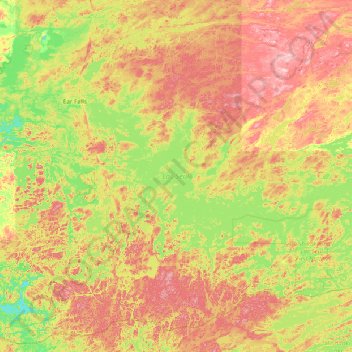
Name: Lac Seul topographic map, elevation, terrain.
Average elevation: 388 m
Minimum elevation: 325 m
Maximum elevation: 483 m
Make a donation
Gear up for your next adventure:
As an Amazon Associate, this site earns from qualifying purchases at no extra cost to you.
Other topographic maps
Click on a map to view its topography, its elevation and its terrain.
Slate Islands
Canada > Ontario > Kenora District > Unorganized Kenora District
Average elevation: 322 m
Galbraith Lake
Canada > Ontario > Kenora District > Unorganized Kenora District
Average elevation: 455 m
Make a donation
Gear up for your next adventure:
As an Amazon Associate, this site earns from qualifying purchases at no extra cost to you.
Loveland Lake
Canada > Ontario > Kenora District > Unorganized Kenora District
Average elevation: 426 m
Make a donation
Gear up for your next adventure:
As an Amazon Associate, this site earns from qualifying purchases at no extra cost to you.
Banana Island
Canada > Ontario > Kenora District > Unorganized Kenora District
Average elevation: 359 m
Ghost Island
Canada > Ontario > Kenora District > Unorganized Kenora District
Average elevation: 401 m
Make a donation
Gear up for your next adventure:
As an Amazon Associate, this site earns from qualifying purchases at no extra cost to you.
Forbes Lake
Canada > Ontario > Kenora District > Sioux Narrows-Nestor Falls Township
Average elevation: 373 m
Sioux Narrows
Canada > Ontario > Kenora District > Sioux Narrows-Nestor Falls Township
Average elevation: 329 m
Make a donation
Gear up for your next adventure:
As an Amazon Associate, this site earns from qualifying purchases at no extra cost to you.