
Kirchseelte topographic map
Interactive map
Click on the map to display elevation.
About this map
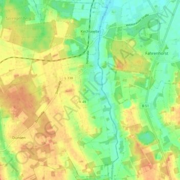
Name: Kirchseelte topographic map, elevation, terrain.
Average elevation: 30 m
Minimum elevation: 12 m
Maximum elevation: 46 m
Other topographic maps
Click on a map to view its topography, its elevation and its terrain.
Dünsen
Germany > Lower Saxony > Landkreis Oldenburg
Dünsen, Samtgemeinde Harpstedt, Landkreis Oldenburg, Lower Saxony, Germany
Average elevation: 38 m
Dötlingen
Germany > Lower Saxony > Landkreis Oldenburg > Dötlingen
Dötlingen, Landkreis Oldenburg, Lower Saxony, 27801, Germany
Average elevation: 31 m
Wildeshausen
Germany > Lower Saxony > Landkreis Oldenburg
Wildeshausen, Landkreis Oldenburg, Lower Saxony, 27793, Germany
Average elevation: 37 m