
Mica Peak topographic map
Interactive map
Click on the map to display elevation.
Mica Peak
Mica Peak is the name of two separate mountain summits in the United States located approximately 5.49 miles (9 km) apart; one in Spokane County, Washington and the other in Kootenai County, Idaho. The two peaks are located along the same ridge, which separates the Spokane Valley and Rathdrum Prairie from the Palouse. The mountains have an elevation difference of only 31 ft (9.4 m) and are the southernmost peaks of the Selkirk Mountains.
About this map
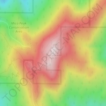
Name: Mica Peak topographic map, elevation, terrain.
Location: Mica Peak, Spokane County, Washington, United States (47.57335 -117.08174 47.57345 -117.08164)
Average elevation: 1,311 m
Minimum elevation: 990 m
Maximum elevation: 1,583 m
Other topographic maps
Click on a map to view its topography, its elevation and its terrain.
Spokane
United States > Washington > Spokane County
Spokane is located on the Spokane River in eastern Washington at an elevation of 1,843 feet (562 m) above sea level, about 18 miles (29 km) from Idaho, 92 miles (148 km) south of the Canadian border, 229 miles (369 km) due east of Seattle, and 279 miles (449 km) southwest of Calgary. The lowest elevation in…
Average elevation: 655 m
Liberty Lake
United States > Washington > Spokane County
Areas east of Liberty Lake Road and areas north of Appleway Road lie on the relatively flat land along the floor of the Spokane Valley. Elevations there range from between 2,000 feet above sea level at the river to around 2,150 feet around Liberty Lake Elementary School. The areas west of Liberty Lake Road and…
Average elevation: 644 m
East Spokane
United States > Washington > Spokane County > Spokane Valley > East Spokane
Average elevation: 625 m
Cheney
United States > Washington > Spokane County
Cheney is located at 47°29′19″N 117°34′43″W / 47.48861°N 117.57861°W / 47.48861; -117.57861 (47.488634, -117.578581), at an elevation of 2,400 ft (730 m).
Average elevation: 725 m