
Puerto Limon topographic map
Interactive map
Click on the map to display elevation.
About this map
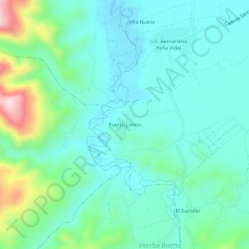
Name: Puerto Limon topographic map, elevation, terrain.
Average elevation: 1,457 m
Minimum elevation: 1,377 m
Maximum elevation: 1,744 m
Other topographic maps
Click on a map to view its topography, its elevation and its terrain.
Samaipata
Bolivia > Santa Cruz > Provincia Florida > Municipio Samaipata
Samaipata or Samaypata (Quechua samay to rest, pata elevated place / above, at the top / edge, bank (of a river), shore) is a small town in the Florida Province of the Santa Cruz Department in Bolivia. It has a subtropical climate and an altitude of 1600–1800 m. It lies about 120 kilometers to the southwest…
Average elevation: 1,695 m