
sedlo Váha topographic map
Interactive map
Click on the map to display elevation.
About this map
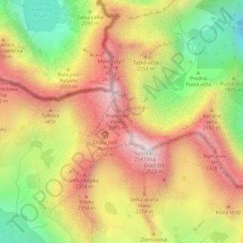
Name: sedlo Váha topographic map, elevation, terrain.
Average elevation: 2,016 m
Minimum elevation: 1,430 m
Maximum elevation: 2,528 m
Other topographic maps
Click on a map to view its topography, its elevation and its terrain.
Rysy
Slovakia > Region of Prešov > District of Poprad > Vysoké Tatry
It is possible to reach the peak from the Slovak side, starting at Štrbské pleso and passing Chata pod Rysmi, a mountain chalet at an altitude of 2,250 m (7,380 ft). Between November 1 and June 15, the trail and chalet on the Slovak side are closed.
Average elevation: 2,005 m
Druhý Mních / Zadni Mnich
Slovakia > Region of Prešov > District of Poprad > Vysoké Tatry
Average elevation: 1,921 m