
Bengkulu topographic map
Interactive map
Click on the map to display elevation.
About this map
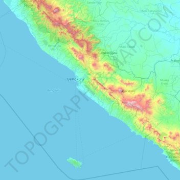
Name: Bengkulu topographic map, elevation, terrain.
Location: Bengkulu, Sumatra, Indonesia (-5.71899 100.62049 -2.28865 103.78107)
Average elevation: 181 m
Minimum elevation: 0 m
Maximum elevation: 3,051 m
Other topographic maps
Click on a map to view its topography, its elevation and its terrain.
Mount Kerinci
Mount Kerinci (Kerinci: Gunung Kincai, Minangkabau: Gunuang Kurinci, Indonesian: Gunung Kerinci), also spelled Kerintji, is an active stratovolcano and the highest mountain in Sumatra, Indonesia. At 12,484 ft (3,805 m) above sea level, it provides Sumatra with the fifth-highest maximum elevation of any island…
Average elevation: 3,229 m