
Make a donation
Gear up for your next adventure:
As an Amazon Associate, this site earns from qualifying purchases at no extra cost to you.
Altenstein topographic map
Click on the map to display elevation.
Make a donation
Gear up for your next adventure:
As an Amazon Associate, this site earns from qualifying purchases at no extra cost to you.
About this map
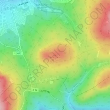
Name: Altenstein topographic map, elevation, terrain.
Average elevation: 424 m
Minimum elevation: 340 m
Maximum elevation: 538 m
Make a donation
Gear up for your next adventure:
As an Amazon Associate, this site earns from qualifying purchases at no extra cost to you.
Other topographic maps
Click on a map to view its topography, its elevation and its terrain.
Neuhof
Deutschland > Hessen > Rheingau-Taunus-Kreis > Taunusstein
Naturräumlich gesehen gehört Neuhof zum „Westlichen Hintertaunus“. Die Topographie weist Geländehöhen zwischen 380 m über NHN (Ortsmittelpunkt) und 505 m über NHN (Siedlung Platte) auf (Angaben aus dem Regionalen Raumordnungsplan Südhessen 1995).
Average elevation: 444 m
Make a donation
Gear up for your next adventure:
As an Amazon Associate, this site earns from qualifying purchases at no extra cost to you.