
Wodehouse Kop topographic map
Interactive map
Click on the map to display elevation.
About this map
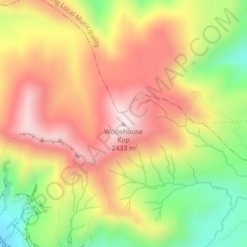
Name: Wodehouse Kop topographic map, elevation, terrain.
Average elevation: 2,199 m
Minimum elevation: 1,912 m
Maximum elevation: 2,439 m
Other topographic maps
Click on a map to view its topography, its elevation and its terrain.
Bethlehem
South Africa > Free State > Thabo Mofutsanyana District Municipality > Dihlabeng Local Municipality
The city lies at an altitude of 1,700 metres (5,600 ft) and this contributes to its cool climate with frosty winters and mild summers. The average annual temperature is around 14 °C (57 °F).
Average elevation: 1,675 m
Fouriesburg
South Africa > Free State > Thabo Mofutsanyana District Municipality > Dihlabeng Local Municipality
Average elevation: 1,745 m