
Mangunreja topographic map
Interactive map
Click on the map to display elevation.
About this map
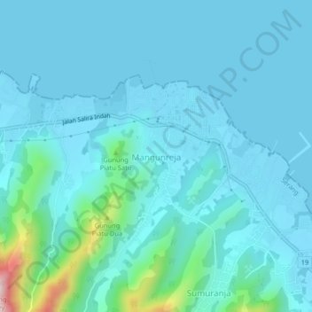
Name: Mangunreja topographic map, elevation, terrain.
Location: Mangunreja, Serang, Banten, Java, Indonesia (-5.91128 106.04664 -5.87128 106.08664)
Average elevation: 42 m
Minimum elevation: -1 m
Maximum elevation: 371 m
Other topographic maps
Click on a map to view its topography, its elevation and its terrain.