
Fletcher topographic map
Interactive map
Click on the map to display elevation.
About this map
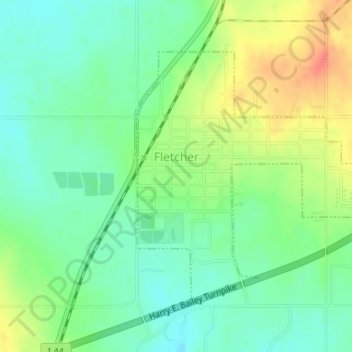
Name: Fletcher topographic map, elevation, terrain.
Location: Fletcher, Comanche County, Oklahoma, United States (34.81210 -98.24795 34.83118 -98.22141)
Average elevation: 417 m
Minimum elevation: 398 m
Maximum elevation: 447 m
Other topographic maps
Click on a map to view its topography, its elevation and its terrain.
Academic Hights
United States > Oklahoma > Comanche County > Lawton
Academic Hights, Lawton, Comanche County, Oklahoma, United States
Average elevation: 348 m
Jackson Hole
United States > Oklahoma > Comanche County
Jackson Hole, Comanche County, Oklahoma, United States
Average elevation: 406 m
Meers
United States > Oklahoma > Comanche County
Meers, Comanche County, Oklahoma, United States
Average elevation: 457 m
Lake Lawtonka
United States > Oklahoma > Comanche County
Lake Lawtonka, Comanche County, Oklahoma, United States
Average elevation: 428 m
Lawton
United States > Oklahoma > Comanche County
Lawton, Comanche County, Oklahoma, United States
Average elevation: 352 m
Indiahoma
United States > Oklahoma > Comanche County
Indiahoma, Comanche County, Oklahoma, United States
Average elevation: 405 m
Geronimo
United States > Oklahoma > Comanche County
Geronimo, Comanche County, Oklahoma, 73543, United States
Average elevation: 328 m
Chattanooga
United States > Oklahoma > Comanche County
Chattanooga, Comanche County, Oklahoma, 73528, United States
Average elevation: 347 m
Faxon
United States > Oklahoma > Comanche County
Faxon, Comanche County, Oklahoma, United States
Average elevation: 334 m
Sterling
United States > Oklahoma > Comanche County
Sterling, Comanche County, Oklahoma, 73567, United States
Average elevation: 372 m
Cache
United States > Oklahoma > Comanche County
Cache, Comanche County, Oklahoma, 73527, United States
Average elevation: 386 m
Fort Sill
United States > Oklahoma > Comanche County
Fort Sill, Comanche County, Oklahoma, United States
Average elevation: 417 m
Elk Mountain
United States > Oklahoma > Comanche County
Elk Mountain, Comanche County, Oklahoma, United States
Average elevation: 543 m
Elgin
United States > Oklahoma > Comanche County
Elgin, Comanche County, Oklahoma, United States
Average elevation: 393 m
Pratt Hill
United States > Oklahoma > Comanche County
Pratt Hill, Comanche County, Oklahoma, 73557, United States
Average elevation: 442 m
Lawton
United States > Oklahoma > Comanche County > Lawton
Lawton, Comanche County, Oklahoma, 73501, United States
Average elevation: 361 m
Mount McKinley
United States > Oklahoma > Comanche County
Mount McKinley, Comanche County, Oklahoma, United States
Average elevation: 498 m
Cove Acres
United States > Oklahoma > Comanche County > Cove Acres
Cove Acres, Comanche County, Oklahoma, 73006, United States
Average elevation: 381 m
Cross Mountain
United States > Oklahoma > Comanche County
Cross Mountain, Comanche County, Oklahoma, United States
Average elevation: 530 m
Medicine Park
United States > Oklahoma > Comanche County
Medicine Park, Comanche County, Oklahoma, 73557, United States
Average elevation: 429 m