
Sebago topographic map
Interactive map
Click on the map to display elevation.
Sebago
According to the United States Census Bureau, the town has a total area of 48.93 square miles (126.73 km2), of which 32.76 square miles (84.85 km2) is land and 16.17 square miles (41.88 km2) is water. Situated beside Sebago Lake, Sebago is drained by the Northwest River and Mill Brook. Douglas Mountain has an elevation of 1,416 feet (432 m) above sea level, the highest point in both the town and southwestern Maine.
About this map
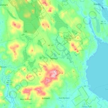
Name: Sebago topographic map, elevation, terrain.
Location: Sebago, Cumberland County, Maine, 04029, United States (43.83376 -70.75793 43.96182 -70.53564)
Average elevation: 160 m
Minimum elevation: 75 m
Maximum elevation: 419 m
Other topographic maps
Click on a map to view its topography, its elevation and its terrain.
New Gloucester
United States > Maine > Cumberland County
The privately owned, unattended Cliff Dow Airport is located on Highview Drive, two miles southwest of New Gloucester, to the east of Interstate 95. Its FAA identifier is 54ME, and it was activated in 2006. Its unpaved runway headings are 5 (for landings) and 23 (for takeoffs) with an AMSL elevation of 415…
Average elevation: 87 m
Scarborough
United States > Maine > Cumberland County
According to the United States Census Bureau, the town has a total area of 70.63 square miles (182.93 km2), of which 47.61 square miles (123.31 km2) is land and 23.02 square miles (59.62 km2) is water. Drained by the Scarborough River, Nonesuch River, Libby River and Spurwink River, the town is situated beside…
Average elevation: 17 m