
Make a donation
Gear up for your next adventure:
As an Amazon Associate, this site earns from qualifying purchases at no extra cost to you.
Chilliwack Lake topographic map
Click on the map to display elevation.
Make a donation
Gear up for your next adventure:
As an Amazon Associate, this site earns from qualifying purchases at no extra cost to you.
About this map
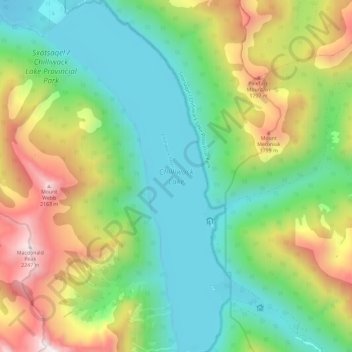
Name: Chilliwack Lake topographic map, elevation, terrain.
Average elevation: 1,152 m
Minimum elevation: 591 m
Maximum elevation: 2,252 m
Make a donation
Gear up for your next adventure:
As an Amazon Associate, this site earns from qualifying purchases at no extra cost to you.
Other topographic maps
Click on a map to view its topography, its elevation and its terrain.
Cheam Peak
Canada > British Columbia > Fraser Valley Regional District > Area E (Chilliwack River Valley)
Average elevation: 1,471 m
Airplane Basin Falls
Canada > British Columbia > Fraser Valley Regional District > Area E (Chilliwack River Valley)
Average elevation: 1,487 m
Airplane Basin Falls
Canada > British Columbia > Fraser Valley Regional District > Area E (Chilliwack River Valley)
Average elevation: 1,487 m
Tamihi Rapids
Canada > British Columbia > Fraser Valley Regional District > Area E (Chilliwack River Valley)
Average elevation: 252 m
Make a donation
Gear up for your next adventure:
As an Amazon Associate, this site earns from qualifying purchases at no extra cost to you.
Mount Mercer
Canada > British Columbia > Fraser Valley Regional District > Area E (Chilliwack River Valley)
Average elevation: 1,359 m