
Lothersdale topographic map
Interactive map
Click on the map to display elevation.
About this map
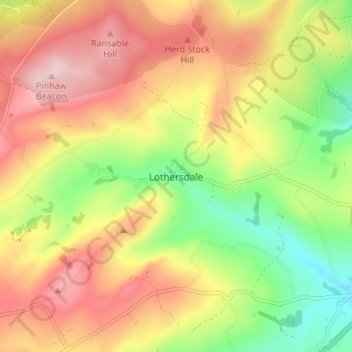
Name: Lothersdale topographic map, elevation, terrain.
Average elevation: 265 m
Minimum elevation: 136 m
Maximum elevation: 386 m
North Yorkshire trails, hiking, mountain biking, running and outdoor activities
Other topographic maps
Click on a map to view its topography, its elevation and its terrain.
River Aire
United Kingdom > England > North Yorkshire > Craven District > Malham > Hanlith
Average elevation: 237 m
Grimwith Reservoir
United Kingdom > England > North Yorkshire > Craven District
Average elevation: 320 m
Bastow Wood
United Kingdom > England > North Yorkshire > Craven District > Conistone
Average elevation: 244 m