
Thank you for supporting this site ❤️
Make a donation
Make a donation
Gear up for your next adventure:
As an Amazon Associate, this site earns from qualifying purchases at no extra cost to you.
Pinya topographic map
Click on the map to display elevation.
Thank you for supporting this site ❤️
Make a donation
Make a donation
Gear up for your next adventure:
As an Amazon Associate, this site earns from qualifying purchases at no extra cost to you.
About this map
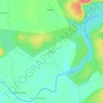
Name: Pinya topographic map, elevation, terrain.
Location: Pinya, Vidisha Tahsil, Vidisha, Madhya Pradesh, 464651, India (23.46468 77.61306 23.50468 77.65306)
Average elevation: 444 m
Minimum elevation: 420 m
Maximum elevation: 502 m
Thank you for supporting this site ❤️
Make a donation
Make a donation
Gear up for your next adventure:
As an Amazon Associate, this site earns from qualifying purchases at no extra cost to you.
Other topographic maps
Click on a map to view its topography, its elevation and its terrain.
Shamshabad Reserved Forest
India > Madhya Pradesh > Vidisha Tahsil > Hinotiya
Average elevation: 469 m