
Puthuppally topographic map
Interactive map
Click on the map to display elevation.
About this map
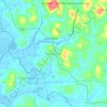
Name: Puthuppally topographic map, elevation, terrain.
Location: Puthuppally, Kottayam, Kerala, 686011, India (9.53930 76.55194 9.57930 76.59194)
Average elevation: 18 m
Minimum elevation: -3 m
Maximum elevation: 79 m
Other topographic maps
Click on a map to view its topography, its elevation and its terrain.
Kottayam
Kottayam has an average elevation of 3 metres (9.8 ft) above sea level. and is situated in the basin of the Meenachil River and in the basin of the Vembanad backwaters, which are formed from several streams in the Western Ghats in Idukki district. According to the division of places in Kerala based on…
Average elevation: 19 m