
Make a donation
Gear up for your next adventure:
As an Amazon Associate, this site earns from qualifying purchases at no extra cost to you.
Englewood topographic map
Click on the map to display elevation.
Make a donation
Gear up for your next adventure:
As an Amazon Associate, this site earns from qualifying purchases at no extra cost to you.
Englewood
Englewood features a diverse topography characterized by flat coastal plains and gently rolling terrain. The area is predominantly low-lying, with elevations rarely exceeding 20 feet above sea level, making it susceptible to tidal influences from the Gulf of Mexico. The landscape is interspersed with wetlands, estuaries, and salt marshes, particularly around Lemon Bay, which provide rich habitats for wildlife. Along the coastline, sandy beaches stretch for miles, offering a scenic backdrop against the turquoise waters. Inland, the terrain transitions into residential neighborhoods and parks, with sporadic pockets of vegetation, including pine and palm trees, contributing to the region's natural beauty.
Make a donation
Gear up for your next adventure:
As an Amazon Associate, this site earns from qualifying purchases at no extra cost to you.
About this map
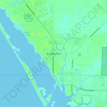
Name: Englewood topographic map, elevation, terrain.
Location: Englewood, Sarasota County, Florida, FL 34223, USA (26.92201 -82.39260 27.00201 -82.31260)
Average elevation: 3 m
Minimum elevation: -1 m
Maximum elevation: 11 m
Make a donation
Gear up for your next adventure:
As an Amazon Associate, this site earns from qualifying purchases at no extra cost to you.