

Naples topographic map
Click on the map to display elevation.
Naples
The city is situated on the Gulf of Naples, on the western coast of southern Italy; it rises from sea level to an elevation of 450 metres (1,480 ft). The small rivers which formerly crossed the centre of the city have since been covered over by construction. It lies between two notable volcanic regions, Mount Vesuvius and the Campi Flegrei (English: Phlegraean Fields). The islands of Procida, Capri and Ischia can all be reached from Naples by hydrofoils and ferries. Sorrento and the Amalfi Coast are situated south of the city, while the Roman ruins of Pompeii, Herculaneum, Oplontis and Stabiae, which were destroyed in the eruption of Vesuvius in 79 AD, are also visible nearby. The port towns of Pozzuoli and Baia, which were part of the Roman naval facility of Portus Julius, lie to the west of the city.
About this map
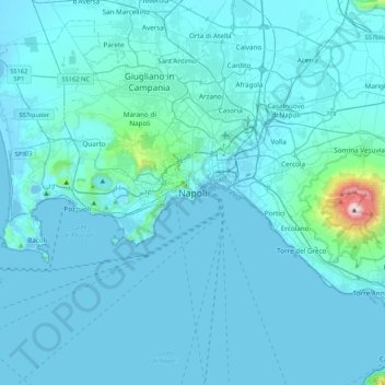
Name: Naples topographic map, elevation, terrain.
Location: Naples, Napoli, Campania, 80100, Italy (40.67593 14.08878 40.99593 14.40878)
Average elevation: 58 m
Minimum elevation: -3 m
Maximum elevation: 1,253 m