
苗栗市 topographic map
Interactive map
Click on the map to display elevation.
About this map
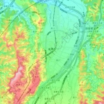
Name: 苗栗市 topographic map, elevation, terrain.
Location: 苗栗市, 苗栗縣, 臺灣 (24.51869 120.77833 24.59915 120.84517)
Average elevation: 80 m
Minimum elevation: 2 m
Maximum elevation: 220 m
苗栗市為河谷平原、多丘陵(西山丘陵)之地區,最高點為西南方的上南勢坑(南勢溪源頭附近)、八甲附近與西湖鄉界的稜線上,海拔達240公尺,往北至「西山尾」,台6線周圍一帶之海拔已降到50公尺左右(後龍溪下游河畔,後龍溪南岸)。氣候屬於亞熱帶季風氣候,氣候溫和多雨,雨量由海岸向山區遞減,雨季主要在5月至9月。
Other topographic maps
Click on a map to view its topography, its elevation and its terrain.