
Essa topographic map
Click on the map to display elevation.
About this map
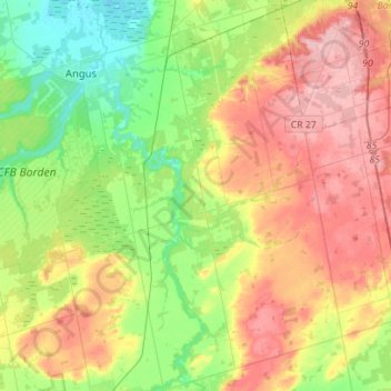
Name: Essa topographic map, elevation, terrain.
Location: Essa, Simcoe County, Central Ontario, Ontario, Canada (44.16238 -79.92278 44.36198 -79.70430)
Average elevation: 244 m
Minimum elevation: 183 m
Maximum elevation: 321 m
Other topographic maps
Click on a map to view its topography, its elevation and its terrain.
Penatanguishene Memorial Park
Canada > Ontario > Simcoe County > Penetanguishene
Average elevation: 210 m
Mara Provincial Park
Canada > Ontario > Simcoe County > Ramara Township > Atherley
Average elevation: 220 m
Wasaga Beach Provincial Park
Canada > Ontario > Simcoe County > Wasaga Beach
The Town of Wasaga Beach covers an area of 61.13 square kilometres (23.60 sq mi) comprised predominantly of sand and loamy sand that exhibit excessive to good drainage and irregular to moderately sloping topography. The poor soil quality makes it difficult to sustain lush lawns in the town. The Canada Land…
Average elevation: 188 m
Beckwith Island
Canada > Ontario > Simcoe County
The island's highest elevation is 226 meters (741 feet) above sea level. Like its populated neighbour Christian Island to the west, and Hope Island to the northwest, the uninhabited island is part of an Ojibwa reserve. On the mainland, Cedar Point lies directly south of the island and Thunder Beach is located…
Average elevation: 185 m
Waubashene Beaches Provincial Park
Canada > Ontario > Simcoe County > Tay > Waubaushene
Average elevation: 189 m
Springhurst Beach
Canada > Ontario > Simcoe County > Wasaga Beach > Springhurst Beach
Average elevation: 184 m
West Holland River (old)
Canada > Ontario > Simcoe County > Bradford West Gwillimbury
Average elevation: 222 m