Geolocate

Nannup topographic map

Click on the map to display elevation.

About this map

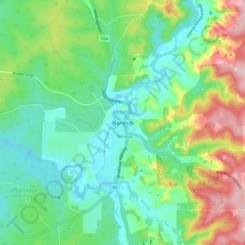
Name: Nannup topographic map, elevation, terrain.

Location: Nannup, Western Australia, 6275, Australia (-34.01843 115.72377 -33.93843 115.80377)

Average elevation: 132 m

Minimum elevation: 60 m

Maximum elevation: 287 m

Gear up for your next adventure:

🔥Reusable Hand Warmers - Maintain dexterity in your fingers for precise map handling
🧺Mesh Stuff Sacks - Breathable storage for wet gear or camp organization
🚲Cycling GPS Computers - Track elevation and topographic routes on two wheels
🧘Folding Sit Mats - Dry and warm seat for map-reading breaks on damp ground
🚶Walking Pedometers - Simple distance tracking for casual trail walkers

As an Amazon Associate, this site earns from qualifying purchases at no extra cost to you.