
State College topographic map
Interactive map
Click on the map to display elevation.
State College
State College is situated at an elevation of approximately 1,200 feet (370 m) above sea level. According to the U.S. Census Bureau, the borough has a total area of 4.5 square miles (12 km2), all of it land. It is surrounded by large tracts of farmland, and an expanse of Appalachian Mountain ranges and forests. Its location within a valley makes it prone to frequent rain and snowfall. Nittany Mountain is part of Pennsylvania's geologic ridge-and-valley province of the Appalachian Mountains. It is (approximately) the geographic center of Pennsylvania.
About this map
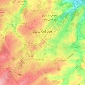
Name: State College topographic map, elevation, terrain.
Location: State College, Centre County, Pennsylvania, United States (40.76837 -77.88617 40.80723 -77.81900)
Average elevation: 351 m
Minimum elevation: 286 m
Maximum elevation: 398 m
Other topographic maps
Click on a map to view its topography, its elevation and its terrain.
Dalevue Park
United States > Pennsylvania > Centre County > State College > Dalevue
Average elevation: 331 m