
Ledyard topographic map
Interactive map
Click on the map to display elevation.
About this map
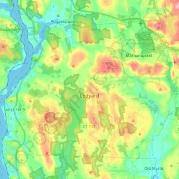
Name: Ledyard topographic map, elevation, terrain.
Location: Ledyard, New London County, Connecticut, United States (41.39765 -72.09662 41.48740 -71.94241)
Average elevation: 53 m
Minimum elevation: -3 m
Maximum elevation: 151 m
Other topographic maps
Click on a map to view its topography, its elevation and its terrain.
Gales Ferry
United States > Connecticut > New London County > Ledyard > Gales Ferry
Gales Ferry, Ledyard, New London County, Connecticut, 06335, United States
Average elevation: 24 m