

Berkeley topographic map
Click on the map to display elevation.
Berkeley
In 1866, Oakland's private College of California looked for a new site. It settled on a location north of Oakland along the foot of the Contra Costa Range (later called the Berkeley Hills) astride Strawberry Creek, at an elevation of about 500 feet (150 m) above the bay, commanding a view of the Bay Area and the Pacific Ocean through the Golden Gate.
About this map
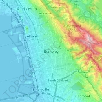
Name: Berkeley topographic map, elevation, terrain.
Location: Berkeley, Alameda County, California, United States (37.83569 -122.36869 37.90669 -122.23420)
Average elevation: 109 m
Minimum elevation: -5 m
Maximum elevation: 570 m
Other topographic maps
Click on a map to view its topography, its elevation and its terrain.

Berkeley Hills
United States > California > Alameda County > Berkeley
The Berkeley Hills are bounded by the major Hayward Fault along their western base, and the minor Wildcat fault on their eastern side. The highest peaks are Grizzly Peak with an elevation of 1,754 feet (535 m) and Round Top, an extinct volcano with an elevation of 1,761 feet (537 m) and William Rust Summit at…
Average elevation: 158 m

Lake Chabot - Main Entrance
United States > California > Alameda County > Castro Valley
Average elevation: 109 m
Berkeley Hills
United States > California > Alameda County > Berkeley
The Berkeley Hills are bounded by the major Hayward Fault along their western base, and the minor Wildcat fault on their eastern side. The highest peaks are Grizzly Peak with an elevation of 1,754 feet (535 m) and Round Top, an extinct volcano with an elevation of 1,761 feet (537 m) and William Rust Summit at…
Average elevation: 158 m
Coyote Hills Regional Park
United States > California > Alameda County > Fremont
Average elevation: 5 m
Contra Costa Rock Park
United States > California > Alameda County > Berkeley
Average elevation: 113 m

Drawbridge
United States > California > Alameda County > Fremont
Drawbridge (formerly Saline City) is a ghost town with an abandoned railroad station located at the southern end of the San Francisco Bay, next to Station Island, now a part of the city of Fremont, California, United States. It is located on the Union Pacific Railroad 6 miles (10 km) south of downtown Fremont,…
Average elevation: -1 m