
Schiffmühle topographic map
Interactive map
Click on the map to display elevation.
About this map
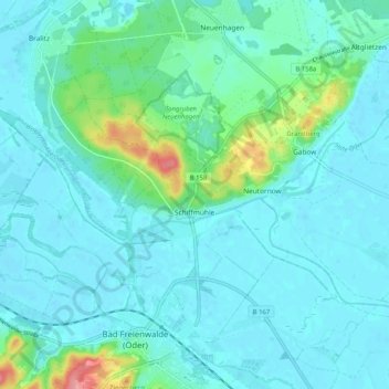
Name: Schiffmühle topographic map, elevation, terrain.
Average elevation: 15 m
Minimum elevation: -1 m
Maximum elevation: 92 m
Other topographic maps
Click on a map to view its topography, its elevation and its terrain.
Sonnenburg
Deutschland > Brandenburg > Märkisch-Oderland > Bad Freienwalde (Oder) > Sonnenburg
Sonnenburg, Bad Freienwalde (Oder), Höhenland, Märkisch-Oderland, Brandenburg, Deutschland
Average elevation: 84 m