
Make a donation
Gear up for your next adventure:
As an Amazon Associate, this site earns from qualifying purchases at no extra cost to you.
Long Burn topographic map
Click on the map to display elevation.
Make a donation
Gear up for your next adventure:
As an Amazon Associate, this site earns from qualifying purchases at no extra cost to you.
About this map
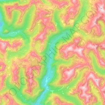
Name: Long Burn topographic map, elevation, terrain.
Average elevation: 721 m
Minimum elevation: 23 m
Maximum elevation: 1,428 m
Make a donation
Gear up for your next adventure:
As an Amazon Associate, this site earns from qualifying purchases at no extra cost to you.
Other topographic maps
Click on a map to view its topography, its elevation and its terrain.
Doubtful Sound
New Zealand > Southland > Southland District > Fiordland Community
Average elevation: 560 m
Milford Sound
New Zealand > Southland > Southland District > Fiordland Community
Average elevation: 655 m
Make a donation
Gear up for your next adventure:
As an Amazon Associate, this site earns from qualifying purchases at no extra cost to you.
Mount Tūtoko
New Zealand > Southland > Southland District > Fiordland Community
Average elevation: 1,892 m
Mitre Peak
New Zealand > Southland > Southland District > Fiordland Community
Average elevation: 657 m
Mount Christina
New Zealand > Southland > Southland District > Fiordland Community
Average elevation: 1,574 m
Donne Glacier
New Zealand > Southland > Southland District > Fiordland Community
Average elevation: 1,826 m
Make a donation
Gear up for your next adventure:
As an Amazon Associate, this site earns from qualifying purchases at no extra cost to you.
Cleddau River
New Zealand > Southland > Southland District > Fiordland Community
Average elevation: 800 m
Mount Elliot
New Zealand > Southland > Southland District > Fiordland Community
Average elevation: 1,110 m
Waimānu / Stirling Falls
New Zealand > Southland > Southland District > Fiordland Community
Average elevation: 423 m
Make a donation
Gear up for your next adventure:
As an Amazon Associate, this site earns from qualifying purchases at no extra cost to you.
Pitt River
New Zealand > Southland > Southland District > Fiordland Community
Average elevation: 706 m
Eldrig Peak
New Zealand > Southland > Southland District > Fiordland Community
Average elevation: 1,155 m
Hineteawa / Bowen Falls
New Zealand > Southland > Southland District > Fiordland Community
Average elevation: 232 m
Make a donation
Gear up for your next adventure:
As an Amazon Associate, this site earns from qualifying purchases at no extra cost to you.
Twin Sisters
New Zealand > Southland > Southland District > Fiordland Community
Average elevation: 1,039 m
Pearl Harbour
New Zealand > Southland > Southland District > Fiordland Community > Manapouri
Average elevation: 212 m
Mount Owen
New Zealand > Southland > Southland District > Fiordland Community
Average elevation: 1,269 m
Make a donation
Gear up for your next adventure:
As an Amazon Associate, this site earns from qualifying purchases at no extra cost to you.
Sutherland Falls
New Zealand > Southland > Southland District > Fiordland Community
Average elevation: 1,006 m
Mitre Peak
New Zealand > Southland > Southland District > Fiordland Community
Average elevation: 657 m
Make a donation
Gear up for your next adventure:
As an Amazon Associate, this site earns from qualifying purchases at no extra cost to you.
Mount Makere
New Zealand > Southland > Southland District > Fiordland Community
Average elevation: 1,433 m
Turner Falls
New Zealand > Southland > Southland District > Fiordland Community
Average elevation: 1,335 m