
Habstetten topographic map
Interactive map
Click on the map to display elevation.
About this map
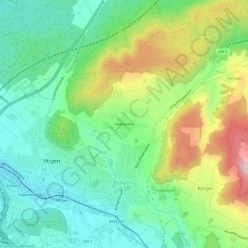
Name: Habstetten topographic map, elevation, terrain.
Average elevation: 655 m
Minimum elevation: 512 m
Maximum elevation: 933 m
Other topographic maps
Click on a map to view its topography, its elevation and its terrain.
Bantiger
Schweiz > Bern > Verwaltungskreis Bern-Mittelland > Bolligen
Bantiger, Bolligen, Verwaltungskreis Bern-Mittelland, Verwaltungsregion Bern-Mittelland, Bern, 3065, Schweiz
Average elevation: 764 m