
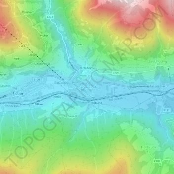
Panzendorf topographic map
Interactive map
Click on the map to display elevation.
About this map
Name: Panzendorf topographic map, elevation, terrain.
Average elevation: 1,345 m
Minimum elevation: 1,063 m
Maximum elevation: 1,990 m
Other topographic maps
Click on a map to view its topography, its elevation and its terrain.
Debanttal
Österreich > Tirol > Bezirk Lienz > Nußdorf-Debant
Debanttal, Nußdorf-Debant, Bezirk Lienz, Tirol, Österreich
Average elevation: 1,741 m
Tristach
Österreich > Tirol > Bezirk Lienz
Tristach, Bezirk Lienz, Tirol, 9907, Österreich
Average elevation: 1,415 m
Marktgemeinde Sillian
Österreich > Tirol > Bezirk Lienz
Marktgemeinde Sillian, Bezirk Lienz, Tirol, 9920, Österreich
Average elevation: 1,702 m
Lienz
Österreich > Tirol > Bezirk Lienz > Stadt Lienz
Lienz, Stadt Lienz, Bezirk Lienz, Tirol, 9900, Österreich
Average elevation: 1,050 m
Gemeinde Obertilliach
Österreich > Tirol > Bezirk Lienz
Gemeinde Obertilliach, Bezirk Lienz, Tirol, 9942, Österreich
Average elevation: 1,853 m
Gemeinde Assling
Österreich > Tirol > Bezirk Lienz
Gemeinde Assling, Bezirk Lienz, Tirol, 9911, Österreich
Average elevation: 1,688 m
Gemeinde Oberlienz
Österreich > Tirol > Bezirk Lienz
Gemeinde Oberlienz, Bezirk Lienz, Tirol, 9903, Österreich
Average elevation: 1,554 m
Gemeinde Ainet
Österreich > Tirol > Bezirk Lienz
Gemeinde Ainet, Bezirk Lienz, Tirol, 9951, Österreich
Average elevation: 1,843 m
Gemeinde Innervillgraten
Österreich > Tirol > Bezirk Lienz > Gemeinde Innervillgraten
Gemeinde Innervillgraten, Bezirk Lienz, Tirol, 9932, Österreich
Average elevation: 2,170 m
Erlach
Österreich > Tirol > Bezirk Lienz > Gemeinde Sankt Jakob in Defereggen > St. Jakob
Erlach, St. Jakob, Gemeinde Sankt Jakob in Defereggen, Bezirk Lienz, Tirol, 9963, Österreich
Average elevation: 1,819 m
Gschlößtal
Österreich > Tirol > Bezirk Lienz > Marktgemeinde Matrei in Osttirol > Außergschlöß
Gschlößtal, Außergschlöß, Marktgemeinde Matrei in Osttirol, Bezirk Lienz, Tirol, Österreich
Average elevation: 2,434 m
Graukogel
Österreich > Tirol > Bezirk Lienz > Marktgemeinde Matrei in Osttirol
Graukogel, Marktgemeinde Matrei in Osttirol, Bezirk Lienz, Tirol, Österreich
Average elevation: 2,650 m
Hirschbichl
Österreich > Tirol > Bezirk Lienz > Gemeinde Sankt Jakob in Defereggen
Hirschbichl, Gemeinde Sankt Jakob in Defereggen, Bezirk Lienz, Tirol, Österreich
Average elevation: 1,989 m
Hochpustertal
Österreich > Tirol > Bezirk Lienz
Hochpustertal, Bezirk Lienz, Tirol, 9920, Österreich
Average elevation: 1,855 m
Gemeinde Kartitsch
Österreich > Tirol > Bezirk Lienz > Gemeinde Kartitsch
Gemeinde Kartitsch, Bezirk Lienz, Tirol, 9941, Österreich
Average elevation: 1,854 m
Gassen
Österreich > Tirol > Bezirk Lienz > Gemeinde St. Veit in Defereggen > Gassen
Gassen, Gemeinde St. Veit in Defereggen, Bezirk Lienz, Tirol, 9962, Österreich
Average elevation: 1,796 m
Gemeinde Untertilliach
Österreich > Tirol > Bezirk Lienz > Gemeinde Untertilliach
Gemeinde Untertilliach, Bezirk Lienz, Tirol, 9943, Österreich
Average elevation: 1,784 m
Hollbruck
Österreich > Tirol > Bezirk Lienz > Gemeinde Kartitsch > Hollbruck
Hollbruck, Gemeinde Kartitsch, Bezirk Lienz, Tirol, 9919, Österreich
Average elevation: 1,379 m
Prägraten
Österreich > Tirol > Bezirk Lienz > Gemeinde Prägraten am Großvenediger
Prägraten, Gemeinde Prägraten am Großvenediger, Bezirk Lienz, Tirol, 9974, Österreich
Average elevation: 1,789 m
Klaunz
Österreich > Tirol > Bezirk Lienz > Marktgemeinde Matrei in Osttirol
Klaunz, Marktgemeinde Matrei in Osttirol, Bezirk Lienz, Tirol, 9971, Österreich
Average elevation: 1,292 m
Gemeinde Virgen
Österreich > Tirol > Bezirk Lienz
Gemeinde Virgen, Bezirk Lienz, Tirol, 9972, Österreich
Average elevation: 2,047 m