
Make a donation
Gear up for your next adventure:
As an Amazon Associate, this site earns from qualifying purchases at no extra cost to you.
Anand topographic map
Click on the map to display elevation.
Make a donation
Gear up for your next adventure:
As an Amazon Associate, this site earns from qualifying purchases at no extra cost to you.
Anand
Anand is located at 22°34′N 72°56′E / 22.57°N 72.93°E / 22.57; 72.93. It has an average elevation of 39 m (128 ft). The city has an area of 22.7 km2 (8.8 sq mi).
Make a donation
Gear up for your next adventure:
As an Amazon Associate, this site earns from qualifying purchases at no extra cost to you.
About this map
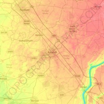
Name: Anand topographic map, elevation, terrain.
Location: Anand, Anand Taluka, Anand District, Gujarat, 388001, India (22.39866 72.80272 22.71866 73.12272)
Average elevation: 40 m
Minimum elevation: 4 m
Maximum elevation: 59 m
Make a donation
Gear up for your next adventure:
As an Amazon Associate, this site earns from qualifying purchases at no extra cost to you.